For generations, the world has largely viewed maps that make Africa appear significantly smaller than its actual size, prompting fresh efforts at the United Nations to change how the continent and other regions are represented geographically. The United Nations General Assembly on Friday adopted a non-binding resolution encouraging governments, schools,……
For generations, the world has largely viewed maps that make Africa appear significantly smaller than its actual size, prompting fresh efforts at the United Nations to change how the continent and other regions are represented geographically.
The United Nations General Assembly on Friday adopted a non-binding resolution encouraging governments, schools, media organisations and other institutions to consider using the Equal Earth projection, a map designed to preserve the actual proportions of the world’s landmasses more accurately.
The resolution, introduced by Togo on behalf of the African Group and supported by the African Union, was approved by 164 countries, with the United States voting against it and six countries — Serbia, Estonia, Georgia, Lithuania, Moldova and Ukraine — abstaining.
The measure, titled “Correct the Map: Rebalancing global cartographic representation and promoting equitable representation of the world’s regions, particularly Africa,” calls for greater use of equal-area maps where accurately depicting the relative size of continents is important.
Read Also: UN Backs New Map Showing Africa’s True Size
However, the resolution does not prohibit the use of the widely known Mercator projection or require countries and institutions to replace it with Equal Earth.
Why Mercator makes Africa look smaller
The Mercator projection was developed by Flemish cartographer Gerardus Mercator in 1569, primarily as a navigational tool for sailors.
While the projection is useful for preserving directions and making shapes relatively familiar, it significantly distorts the size of landmasses, particularly as they move farther from the Equator.
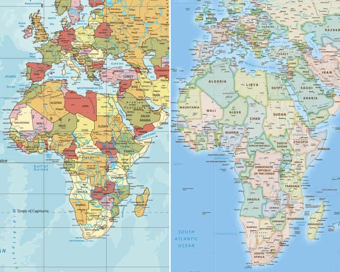
As a result, regions such as Greenland and northern Europe appear much larger than they are in reality, while Africa and other areas closer to the Equator appear comparatively smaller.
On many conventional Mercator maps, Greenland can appear comparable in size to Africa, despite Africa having roughly 14 times the land area of Greenland.
The projection has consequently given Europe and North America a much greater visual presence, while reducing the apparent size of Africa, Latin America and parts of Asia.
How Equal Earth changes the picture
The Equal Earth projection was developed in 2018 by cartographers Bojan Šavrič, Tom Patterson and Bernhard Jenny as an equal-area alternative.
Unlike Mercator, Equal Earth is designed to maintain the correct relative proportions of landmasses while keeping the shapes of continents reasonably familiar.
Africa therefore appears substantially larger on an Equal Earth map, while Greenland, Russia, northern Europe and parts of North America appear smaller in comparison.
Africa’s actual size
Africa covers approximately 30.3 million square kilometres, making it the second-largest continent after Asia, which spans roughly 44 to 45 million square kilometres.
Its size means Africa is larger than five of the world’s other six continents.
North America covers about 24.7 million square kilometres, while South America occupies approximately 17.8 million square kilometres.
Antarctica has an area of about 14 million square kilometres, Europe covers roughly 10.2 to 10.5 million square kilometres, while Australia and Oceania account for about 8.5 to 8.6 million square kilometres.
Africa is therefore roughly three times the size of Europe, about 1.2 times the size of North America, almost twice the size of South America, more than twice the size of Antarctica and more than three times the size of Australia and Oceania.
The continent is also large enough to contain the contiguous United States, China, India and much of Europe within its borders, with land still remaining.
Greenland, by comparison, is only around one-fourteenth the size of Africa.
Latin America covers approximately 20 million square kilometres, while Africa, Latin America, South Asia and Oceania collectively account for more than 60 million square kilometres of land.
Support and opposition to the resolution
Supporters of the UN resolution, particularly African countries, argue that correcting the visual distortion could have implications beyond geography, particularly in education and perceptions of the continent’s importance and scale.
Togo has already moved towards updating its educational geography materials to incorporate the Equal Earth projection, while France has also indicated plans to move away from the traditional Mercator representation.
The United States, however, opposed the resolution, arguing that it promoted an “ideological agenda” and diverted attention from more pressing international challenges.
Despite the vote, the resolution carries no legal obligation for member states.
Its impact will therefore depend largely on whether governments, schools, publishers, media organisations and technology companies voluntarily adopt Equal Earth or other equal-area projections when displaying maps where accurate representation of landmass is important.